• Stories of Restoration
  • State of the Land
    • Reports
    • Tutorials
  • Events and Workshops
  • Dashboard
  • About K4GGWA
  • EN
  • FR

On this page

  • Predictive Modeling in Restoration

What is predictive modelling for landscape restoration?

restoration
machine-learning
monitoring
There is increasing awareness of the need for enhanced use of evidence in the assessment of land degradation status and the factors or drivers that lead to degradation. What has been less focused on is generation for rigorous data and evidence to enable more rigorous predictive modeling to inform land restoration interventions.
Author

CIFOR-ICRAF

Published

October 25, 2024

Predictive Modeling in Restoration

Research suggests that when ecosystems are degraded, it can be challenging to restore them as their degraded state can be highly resilient to change (Suding, Gross, and Houseman (2004)). It is therefore critical to understand the factors that led to degradation in the first place, the current state of land degradation, and to design restoration interventions that address these underlying factors. Recent advances in earth observation, data science, and machine learning have made it possible to generate high-resolution predictive maps of land degradation status and its drivers across large landscapes. When these advances are combined with systematic field data collection, they provide a powerful toolset to inform restoration planning, targeting, and monitoring. By leveraging these technologies, restoration practitioners can make more informed decisions and improve the effectiveness of their interventions.

Despite the recognition of the need for stronger evidence to guide land restoration, large gaps remain in terms of data and evidence. This is partly due to the complexity of the processes leading to land degradation and recovery, including interactions between biophysical and socio-economic factors. Additionally, land degradation and restoration processes often occur over long time scales and large spatial extents, making it difficult to capture and monitor changes effectively.

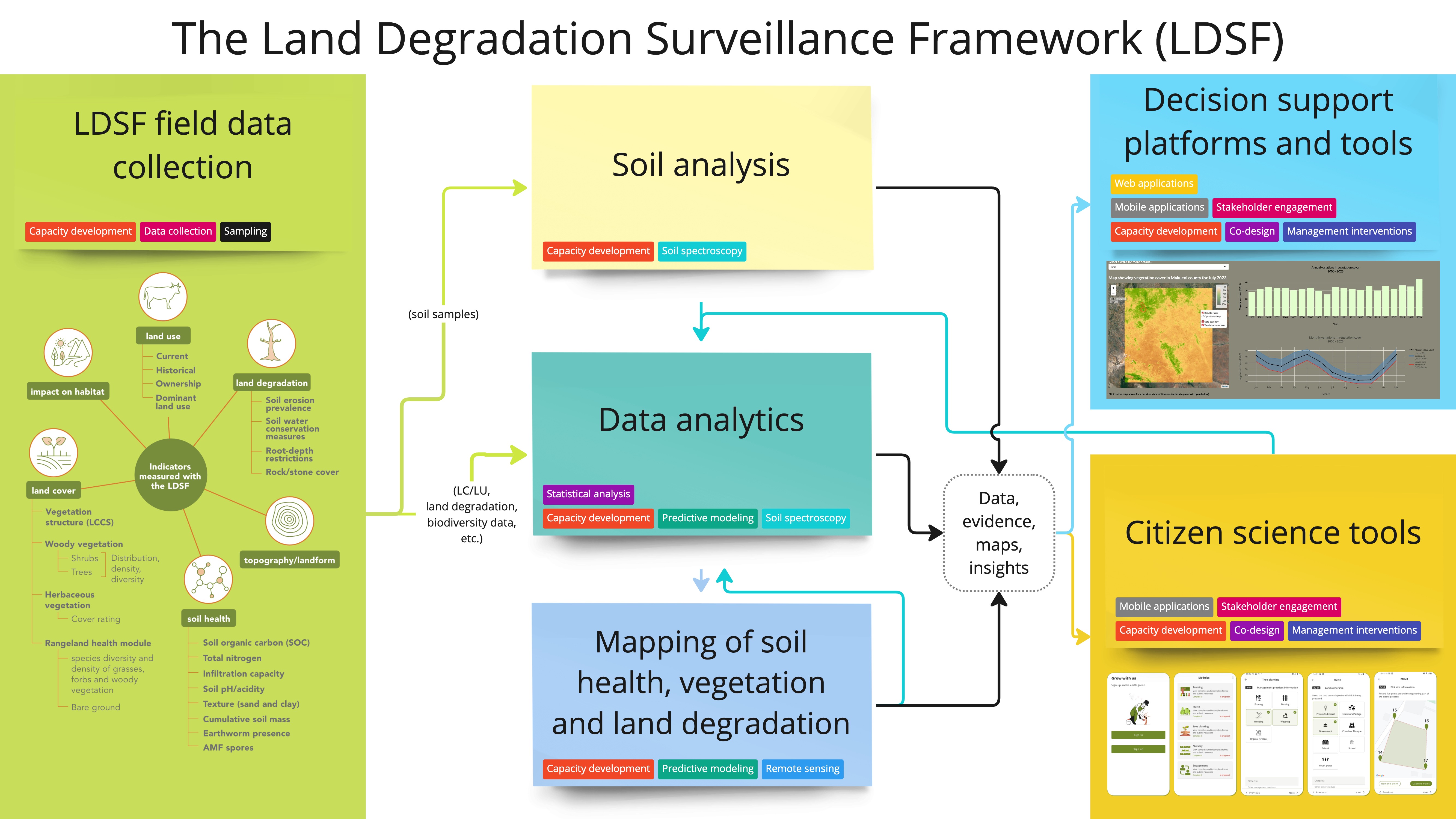
This does not mean that it is impossible to assess and monitor land degradation and recovery over time. In fact, large strides have been made towards more rigorous and scalable solutions for such assessments. The Land Degradation Surveillance Framework (LDSF), for example, has been implemented across more than 40 countries in the tropics to fill these gaps, and to develop systems and tools to bring evidence to decision-makers. It is also well published and has a proven track record having been applied across a diverse portfolio of projects (T.-G. Vågen et al. (2013); T.-G. Vågen and Winowiecki (2013); Winowiecki, Vågen, and Huising (2016); Massawe et al. (2017); Bargués-Tobella et al. (2024)).

The LDSF process. From data collection in the field (left), data analytics (middle), to outputs that help inform and monitor both land degradation status and restoration progress.
Back to top

References

Bargués-Tobella, Aida, Leigh Ann Winowiecki, Douglas Sheil, and Tor-Gunnar Vågen. 2024. “Determinants of Soil Field-Saturated Hydraulic Conductivity Across Sub-Saharan Africa: Texture and Beyond.” Water Resources Research 60 (1): e2023WR035510. https://doi.org/10.1029/2023WR035510.
Massawe, Boniface H. J., Leigh Winowiecki, Joel L. Meliyo, Joseph D. J. Mbogoni, Balthazar Msanya, Didas Kimaro, Jozef Deckers, et al. 2017. “Assessing Drivers of Soil Properties and Classification in the West Usambara Mountains, Tanzania.” Geoderma Regional 11 (October): 141–54. https://doi.org/10.1016/j.geodrs.2017.10.002.
Suding, Katharine N, Katherine L Gross, and Gregory R Houseman. 2004. “Alternative States and Positive Feedbacks in Restoration Ecology.” TRENDS in Ecology and Evolution 19 (1): 46–53. https://doi.org/10.1016/j.tree.2003.10.005.
Vågen, Tor-Gunnar, and Leigh A. Winowiecki. 2013. “Mapping of Soil Organic Carbon Stocks for Spatially Explicit Assessments of Climate Change Mitigation Potential.” Environmental Research Letters 8 (1): 015011. https://doi.org/10.1088/1748-9326/8/1/015011.
Vågen, Tor-G., Leigh A. Winowiecki, Assefa Abegaz, and Kiros M. Hadgu. 2013. “Landsat-Based Approaches for Mapping of Land Degradation Prevalence and Soil Functional Properties in Ethiopia.” Remote Sensing of Environment 134 (July): 266–75. https://doi.org/10.1016/j.rse.2013.03.006.
Winowiecki, Leigh, Tor-Gunnar Vågen, and Jeroen Huising. 2016. “Effects of Land Cover on Ecosystem Services in Tanzania: A Spatial Assessment of Soil Organic Carbon.” Geoderma 263 (February): 274–83. https://doi.org/10.1016/j.geoderma.2015.03.010.

Contact

Email: t.vagen@cifor-icraf.org

SPACIAL Lab
Visit K4GGWA Website →

© 2025 Knowledge for Great Green Wall Action

Funded by
EU Flag
Implemented by
ICRAF FAO